Mapping Out Your Antiquing

Whether your antiquing trips are local or you hit the road to search far and wide, there are a number of antique networks offering maps to help you discover places to haunt & hunt.

antique shopping mapThe Minnesota Antique Network, along with sister state sites Illinois Antique Network.com, Iowa Antique Network, Missouri Antique Network, Nebraska Antique Network, & Wisconsin Antique Network (with plans for more states to follow), offers an easy means for you to map out your antiquing destinations. Along with maps, these sites offer a glimpse into the shops themselves, with photos and descriptions of items available, shop news & events, specialties, etc. This offers the collector, decorator, or avid junker the chance to create a travel or shopping plan that is most likely to appeal to your specific interests and tastes. It is especially helpful if they offer shop hours, so you can plan to get their when they are open.

Of course, some state travel sites and local antique dealer associations offer similar help, as do sites such as AntiqueMalls.com. And I Antique Online offers some shopping directories too. But this currently mostly Midwest network of antique shops by state often makes it easier to start. Plus, each of the state sites has a FaceBook Page as well, which is especially nice for connecting to antique shops in your area. (The shops that have FaceBook pages, anyway.)

Since the shops must pay for placement at these sites, it’s a good idea to always ask the antique store staff what other antique shops are nearby as well as grab the other literature found in the shops so that you won’t miss anything.

PS If you prefer antiquing apps, there’s also the Antique Week app; sadly, it’s only currently available for Apple products like iPhones and iPads. Though there are electronic versions of their Shop Guide directories to use with GPS devices such as Garmin & TOMTOM. The aforementioned antique networks organized by state are also working on mobile versions — fingers-crossed that tech comes soon!

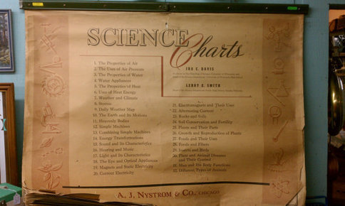
One Of A Kind 18 Page Vintage Science Chart Set by AJ Nystrom Flip Chart HUGE Like Pull Down School Map Illustrated Machines Biology Botony

A vintage set of Science Charts by A. J. Nystrom & Company of Chicago. The 18 pages are bound in a metal mounting — like those pull-down wall

Deanna Dahlsad‘s insight:

Click for the fabuluos pics!

See on www.etsy.com

Authentic Antique Pioneer & Farm Homesteading Ephemera

Found here in North Dakota, this antique promotional booklet is an authentic piece of pioneering & homestead farming history! Compliments of Samuel Lange, a dealer in Farm Machinery, such as Buggies and Carriages, Cream Separators, Plymouth Twine, Defiance Listers & Plows, La Cross Disk Harrows, pioneer Buggies, Surries & Wagons, agent for Queen City Creamery Co. “Highest Paid Prices for Cream.”

Also noted inside the front and back covers, Mc Cormick Binders, Mowers & Hay Rakes, Plano & Mc Cormick repairs, Racine Cultivators & Plows, Wenzelman Steele Grain Dump, Empire Ball Bearing, Neck Bearing Cream Separator.

Inside, the little book from 1908 is filled with facts — from foreign currency conversion to census data, from color maps to business laws, and more. Plus, there are pages for the owner to write down addresses, notes, ledger details, and calender dates.

Booklet measures 5 and 3/4 inches by 3 inches and is available for sale in our Etsy shop. Also included, a small piece of handwritten ephemera which was found inside and we feel should remain with this lovely old piece.

Hidden Values In Antique Collecting & Genealogy In The News

Spending time with my collectibles is a huge part of why I collect — and I don’t mean the dusting! In fact, one of the reasons I blog is because I love the time to spend examining and researching each object. I truly believe this is a huge part of the value of collecting as a hobby.

Two recent news stories reminded me of this fact.

16th-Century Map of Lost Colony

The first is a matter of maps and historical mysteries… The British Museum’s recent re-examination of a 16th-century coastal map of the Tidewater coast of North Carolina has revealed hidden markings that may show what happened to the so-called American Lost Colony. While this colony was the second English settlement on the North Carolina coast, it was the first settlement to include civilians, including the legendary Virginia Dare, the granddaughter of the colony’s governor, John White. Virginia was born within weeks of their arrival to the settlement in 1587 — making Virginia Dare the first child of English descent born in the Americas.

Now, I’m not saying that all map collectors have a map of this magnitude; but even that vintage shell oil map may lead to a discovery, a road not taken, a connection you’ve not made before. Who knows what mysteries you might solve — or even find?

Speaking of connections, this next news story discusses how genealogy may help provide evidence that proves humans are continuing to evolve. Your family tree alone may not seem like much, but when combined with others, it provides scientific information:

“Studying evolution requires large sample sizes with individual-based data covering the entire lifespan of each born person,” said Dr Lummaa. “We need unbiased datasets that report the life events for everyone born. Because natural and sexual selection acts differently on different classes of individuals and across the life cycle, we needed to study selection with respect to these characteristics in order to understand how our species evolves.”

Doesn’t that all just inspire you to go antiquing, to organize those family records? It certainly makes me want to raise that bidding paddle!

Antique Japan Travel Guide For Westerners

There are many charming and antiquated things of note in this antique travel book titled The Club Hotel, Limited: Guide Book of Yokohama, Tokyo and Principal Places in Japan and I thought I’d share a few of them before this book and map sells.

Printed at the “Box Of Curios,” No. 58, Main Street, Yokohama, Japan, there’s no copyright or publication date; but it’s circa 1880s to 1910s. This antique book with blue cloth boards and gilt lettering contains all you’d expect in a guidebook, including hotels, excursions, tea rooms, shopping, bars, geisha, libraries, museums, churches, temples, etc. — including black and white photos, ads for businesses, AND, neatly tucked in the built-in pocket in the back cover, a fragile but pristine color map! (Map opens to roughly 12 1/2 by 8 1/2 inches, so it would not fit completely on the scanner.)

I’ve never longed to travel to the Orient, but if I could travel back in time, perhaps I would change my mind for the book says, “One can go all over Tokyo at any hour unarmed and unannoyed, which one certainly could not surely do in London, Paris, Vienna, or other Western Capitals.”

Apparently, The Club Hotel, Limited was an actual place as there are photos of the building, the entrance, the dining room, and the bar.

According to the text, The Club Hotel, Limited was located “near the landing place (English Hatoba).” More details are found on this page:

Despite The Club Hotel, Limited being a real hotel, this book has ads for many other places rather than really promoting the The Club Hotel, Ltd. (The ads must have paid for the printing, me thinks.) In fact, the first ad in this book, right inside the front cover, is for The Hotel Metropole, “the only hotel in Tokio under European Management.”

Here are some interesting (if racist due to the times) things of note from the text’s Preliminary Remarks:

The Japanese will be found pleasant mannered people. Treated politely, they are invariably polite, and as a rule very kindly disposed towards foreigners. Many of them are incorrigible procrastinators. It is always “to morrow” with them. Hotel servants, however, are often very quick, as well as good and attentive, and seeing so much of foreigners they understand foreign requirements.

The people who stamp about the streets playing a double whistle are blind Shampooers, i.e. “Massage” operators by trade.

Japanese baths are generally heated with charcoal, and it is well to be careful of asphyxia from the fumes. The bath-houses with men and women bathing in full sight of each other, are a curiosity to Europeans.

Geisha or Singing girls, which could be ordered through the tea-house, and are listed on the same page as Japanese Wrestling, Public Libraries, Museums, Places Of Worship, etc. (The scan below also includes the small map of the Temples of Shiba.)

But, of course, the collector in me is most intrigued by all the discussion of “curio shops,” which are heavily advertised in the back of the book.  (Note how the chapter begins promoting the European Curio Shops of Yokohama.)

Most notably, Kuhn & Komor, No. 37, Water Street, Yokohama, which asks you to kindly note the company’s trademark “Stork and Sun” used as a sign board on all their branches.

A few other interesting old ads I’ve scanned will be posted soon!

Vintage Ephemera From Three Lakes, Wisconsin

I love ephemera, so I was thrilled to find this pair of vintage travel ephemera from Three Lakes Wisconsin.

The first piece is a brochure for Three Lakes, Wisconsin, issued by Three Lakes Resort Association, which has black and white (and color photos), showing the usual outdoor vacation stuff… But wait — what’s this? Three Lakes Wisconsin has a woman with a kitten, a baby raccoon — and is that a porcupine?! Get the kids in the car, honey, we’re going to Three Lakes!

The vintage brochure opens to full 17 by 12 inches, with a very large map of the area. There are two notations in red ink on the map — the explanation of which lies in piece of ephemera number two.

The second piece of ephemera is typewritten memorandum note which was tucked inside the brochure. This memo, on the official letterhead of Walter W. Eiler, Realtor, Three Lakes, Wisconsin, is signed in ink by Edwin E. Mueller. Mueller was writing to a Mr. Mohr — some sort of follow-up to a promise to send Mr. Mohr information on the Three Lakes area. In this short note, the red ink marks on the map are explained: “I have marked the location of the two biggest camp sites… The Four Mile camp… The Laurel Lake site.”

(What? No mention of where to find the lady with all the cute baby animals?!)

Also in the note, this charming ending:

Not being a camper myself I am no authority on the subject but I see plenty of people camping at both places in tents, trailers and sleeping bags on the ground so it must be OK. Come up and try it. Stop to see us and if you have any loose change to spend for a lot or what have you we are just the fellows that can make a deal. Thanks again for the good service on Mrs. Muerllers’ glasses.

Ahh, a good salesman leaves no stone unturned!

Looks like Mr. Mohr just tucked the brochure away, memo neatly inside it, and never went camping — perhaps out of fear of being sold some real estate. *wink*

Neither the brochure nor the memo is not dated (other than the 4/3 in the upper right hand corner?) but it appears to be circa late 1940s to 1950s. I’ve listed it at eBay, in case you’ve got to hold this in your own hands *wink*

A Fan of the Map

I do like maps, strongly, not quite enough to love them. Love being such a big word in small letters. I use a map when I explore rural ruins. I use it to find the locations when others tell me they have found an abandoned farmhouse in my area. I have a backroad map which (so far) has been very reliable, even when I’ve taken some pretty far fetched turns.

For his birthday, I gave my nephew two full poster-sized maps. One of Canada and the other of the World. We put them up in his bedroom. Is it only a co-incidence that geography is the subject he seems to be having the most trouble with this year? I hope so. I may not be ready to tell him everything he needs to know about geography but I would like to see him learn about rocks, maps and navigation. One of the most important things in life is knowing how to navigate your way.

I remember the last time I looked at a really old map. I liked seeing the terrors written on there like monsters and the edge of the world. Thanks to cartographers and world explorers and ancient navigators we know the world does not end with a sudden drop. Modern explorers and those into geocaching use a GPS to find their way around. But even then, the old fashioned map is at the root of every exploration.

Old/ Vintage Maps

Hand Drawn Maps